

Founder's Message 28 Dec 2010
ProximityCast became a dream when I got my first GPS and explored it's Points of Interest(POI). POI were fascinating. If you needed a gas station you could search the POI. If you wanted a restaurant, you could search the POI. If you needed a convenience store, you could search the POI to find the nearest convenience store. POI covered a multitude of categories allowing you to find the nearest one needed or desired to your location. While the POI were fascinating, they were also disappointing because they did not include everything. Businesses open and close. Many never found their way into the database of POI
Featured POI
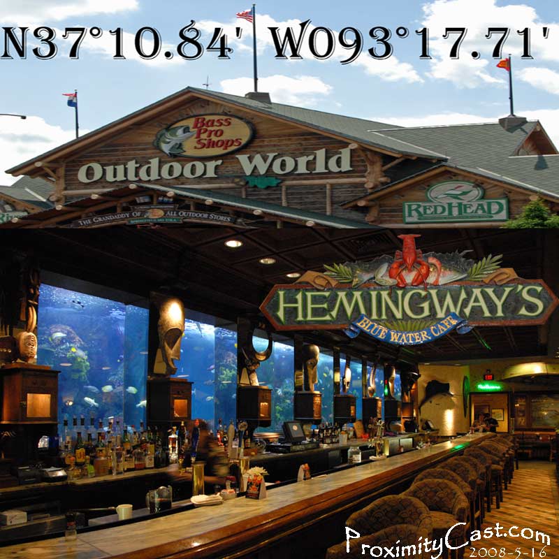
Hemingway's Blue Water Cafe is a fine dining experience found in the Springfield Missouri Bass Pro Shop.
Customers can sit at the bar and enjoy Alligator Tail or another exquisite menu item as they watch exotic fish swim in the super large salt water aquarium. Hemingway's is definitely a Point of Interest worth enjoying if you are in the Springfield, MO area.
The idea for ProximityCast was born. A place where users could add Points of Interest to a database and flag POI that no longer existed to help keep the database current.
ProximityCast is much more than just a means to manage POI. Take a look at the featured POI in the sidebar: Hemingway's Blue Water Cafe. ProximityCast provides an image of the POI allowing the user to get a feel for the ambiance they will encounter should they choose to go to the selected POI. ProximityCast also requires the Latitude and Longitude coordinates to be posted on the POI image. The reason for this is subtle and not readily appreciated by the uninitiated and uneducated masses of potential users, but once the esoteric reason for this requirement is understood it can be greatly appreciated.
Okay Mr. Founder, why do you insist on having the latitude and longitude coordinates on each picture? It just seems a little too pedantic for me! Good question. As a pilot I have long appreciated the power of geographic coordinates. A simple pair of numbers can accurately mark any spot on the face of the earth. Street addresses vary from country to country, but geographic coordinates work anywhere. If you know them, geographic coordinates are much easier to enter into a GPS than most street addresses. If you enter a street address into Google Maps, more often than not the address will not be plotted on the map at the correct spot. You can prove this to yourself by entering a small handful of known street addresses, if you have not already been personally mislead by Google Maps. Give it a try: Google Maps. Personally, I love Google Maps. I have incorporated many of Google's mapping features into ProximityCast to make it a more robust web application. ProximityCast complements Google, Google complements ProximityCast. As the founder of ProximityCast, I love the things that Google does. If and when they do the little extra things that ProximityCast does, I can rest easy and finally forget about the passion that drives me to continue to improve ProximityCast.
One more significant reason for having the coordinates on the POI image: The coordinates serve as the photographer/photo submitter's certification that the location is correct. If you arrive there you will see what the photographer showed in his/her image. No more worries about arriving at an incorrectly posted street address.
I have faced some significant hurdles in making ProximityCast all it can be. Unfortunately I have had to downgrade my ProximityCast endeavor to HOBBY status. It is a hobby I love though and will continue to work at as I am able. ProximityCast is much bigger than your typical webpage. Actually it is a web based application with many useful nuances if you are aware of them. Soon I hope to provide instructional youtube videos to make ProximityCast easy to learn and appreciate. I hope you will track my progress. If you have read all of this message from my Facebook post and LIKE it, please show me by pressing like. If you don't like it, tell me why in a comment. Personally I love ProximityCast, but I fully understand it. It is in Beta and can be considered as only a prototype. There are improvements that are necessary, but as a solo founder with limited resources I am like a turtle attempting to circumnavigate the world.
If you would like to be a part of the ProximityCast team, send me an email detailing what you are able and would like to contribute with your personal contact information to the contact email posted at the bottom of the left info column of this page.
Consider sending me a friend request on Facebook if you are not already a friend.
Follow me on twitter for the latest updates and improvements.
Thank you for your support and encouragement.
Spend some time exploring the site. Let me know your thoughts. What features would you like? What improvements would you like? Do you currently use a GPS?
Kind regards,
David Robert
Founder of ProximityCast.com